
To find out if you are in a flood zone or to have an elevation certificate completed, please call Montgomery Land Surveying at (334) 625-9540 or send us an e-mail with your name, address and phone number to su******@*********************ng.com.
“Thanks Keith – this [flood elevation survey & elevation certificate] helped [our client] a lot – quote went down to $460 – down from $2599.” – Staci Herring, State Farm Insurance
Flood elevation survey through flood maps
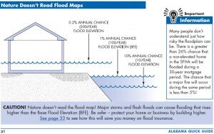
Most all counties in Alabama have completed the process of updating the FEMA Flood Insurance Rate Maps (FIRMs) so that homeowners can understand their risk from flooding. This allows for a more precise flood elevation survey and elevation certificate in a specific area. These maps show the areas of potential flooding based on the 1-percent chance storm event.
This has been known in the past as the 100 year flood and is also known as the Special Flood Hazard Area (SFHA). When you get the amount of rain comprising the 1-percent storm the flood water will come to a certain elevation near your home, known as the Base Flood Elevation (BFE). FEMA is required to assess its flood hazard map inventory at least once every 5 years for flood elevation survey and elevation certificate purposes. But, because of funding shortfalls, it’s been over 15 years for some communities. For those homeowners with a mortgage, purchasing flood insurance is mandatory in a participating community if the loan is federally insured or the lender is regulated by the federal government.
 A flood elevation survey in order for you to purchase flood insurance is highly advisable even if you’re not required to purchase but are located near a stream or lake – get a flood elevation survey and elevation certificate for your home. Remember, the 1-percent chance storm has a 1 percent chance of being met OR EXCEEDED in any year. Over the life of a 30 year mortgage there is a 26% chance of having a flood event that exceeds the base flood elevation. Mortgage insurance rates are generally less the higher above the base flood elevation your finished floor is located. Therefore, if you are four feet above the BFE the rates should be lower than if you were at or below the BFE.
A $300 policy may well be worth the peace of mind it brings. Your homeowner policy has an exclusion from any flood damage. You should also know that just because you’re above the BFE and far away from a running stream, many dry ditches have caused significant damage to a home during a flash flood. Again, your homeowner policy is useless in this case but a flood policy would cover this damage.
Purchasing flood insurance is mandatory…
…if the loan is federally insured or the lender is regulated by the federal government
Elevation Certificate is needed to determine flood insurance rates
 As stated above, your mortgage company may be required to ask you to purchase flood insurance. Of course, they would want you to do so because they are protected also. This would involve you having a flood elevation survey completed which will produce an elevation certificate. You should also know that the mortgage lender may also require flood insurance even if it is determined you don’t need it. This is their prerogative. Again, the rates should be rather low in this case, but there are some costs nonetheless. Now that you know a little about the overall situation, how does this affect you directly? If you are currently shown to be in or near a flood hazard zone, or if you’re going to be in or near a flood hazard on the proposed maps, NOW is the time to act. The following are the possible situations in which you may find yourself:
1. Out of the flood hazard zone completely on the old and new maps. This is great. In this case there is no requirement for the purchase of flood insurance. But, as we said below, if there is ANY risk you might want to consider it. An evaluation of your risk is quick and easy.
2.You’re lot is currently or proposed to be shown in the flood hazard zone as specified in the elevation certificate. This puts you under the requirement for flood insurance. You should have a flood elevation survey and elevation certificate completed to determint the next situation. Your situation may now be one of the following:
a.Your lot is “in” the flood hazard zone but the lowest adjacent grade (LAG) around your house is “out” or above the base flood elevation (BFE). In this situation, it is possible that the flood insurance requirement may be removed. This process is called a Letter of Map Amendment (LOMA).
b.Your lowest adjacent grade (LAG) is below the BFE but the lowest finished floor elevation (FFE) is above the BFE. In this case you need to purchase flood insurance. An Elevation Certificate is necessary as a way to determine your premium rate.
c.Your lowest finished floor elevation (FFE) is below the BFE. This case is similar to 2.b. above but the flood risk is higher. Again, get an elevation certificate to determine your premium rate.
If you’re in situation 2 above, the first step is to get a flood elevation survey and elevation certificate completed. This process is done by a licensed land surveyor who will measure the elevation of your finished floor elevation and the lowest adjacent grade to determine your location relative to the flood hazard zone. This process will produce an Elevation Certificate that can be used to either complete the LOMA process or allow your insurance agent to set the flood insurance premium rate.
One last money saving tip – if the flood insurance rate maps haven’t been printed yet you have the opportunity to obtain flood insurance under the old rates. Then, when the new maps become effective, your rates may remain the same – you will be grandfathered in.
For more specific information about the National Flood Insurance Program and flood determination, see the web at floodsmart.gov. To review FEMA’s Flood Maps in your area, go to FEMA Map Service Center. For homes in the City of Montgomery, you may also check the Montgomery Interactive GIS Maps page.
The land surveyors at Montgomery Land Surveying are eager to discuss your potential flood situation with you. We have lots of experience in this type of work. To talk about your flood elevation survey and elevation certificate needs, please call us today at (334) 625-9540.