↓
 

Montgomery Land Surveying

Land Surveying in Montgomery, Montgomery County, Alabama

Montgomery Land Surveying
  • Home
  • ALTA Survey
  • Boundary Surveying
  • Construction Survey
  • Drone Surveying
  • Elevation Certificate
  • Land Surveying
  • Lot Survey/Closing Survey
  • Topographic Survey
  • Civil Engineering
    • Expert Witness
    • Elevation Certificate – LOMA
  • Contact Us
Home - Page 3 << 1 2 3 4 5 6 7 >>

Post navigation

← Older posts
Newer posts →

The Importance of Land Surveying in the Modern World

Montgomery Land Surveying Posted on August 28, 2012 by MontgomeryLSJanuary 20, 2018

land surveying

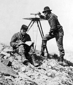
Most of you have probably never thought about land surveying until you needed it at some point. Many of us hear about land surveying all the time but never really give it much thought.

Since an investment in land and/or a home will likely be the largest investment you will ever make in your lifetime, knowing where your property lines are becomes very important indeed.

The art of land surveying was developed centuries ago. In fact, it’s one of the oldest professions in the world. The fact that it was used by man at such an early time and is still being used now shows how important surveying is to our survival.

Surveying land has many uses. Boundary surveying, for instance, allows you to know where your property corners or property lines are. This is especially helpful when disputes with a neighbour or with other people arise in terms of where your property ends.

If your family wants to divide a tract of land and transfer ownership to other family members, a boundary survey is the first step to do so. If you’re having a building constructed, it is very important that you have the land surveyed to make sure that you are not encroaching onto other peoples’ property.

A mistaken building location is very expensive to fix so you might as well invest in a boundary survey to prevent this.

“Land Surveying saves money, time, lives, and properties”.

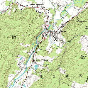
A topographic survey, or topo survey for short, is another important type of land surveying. A topo survey is done to locate natural and man-made features on a particular parcel of land.

A topographic survey is different in that the elevation of the land is surveyed which means it can show man-made underground features, retaining walls, utility lines and etc.

Before you start any kind of construction activity, it’s important to have a topo survey done in the area so they’ll have an accurate record of the land’s existing conditions. Yes, that spot with the new mall in the neighbourhood had to have a topo survey done first.

Now, a flood survey or flood determination – this is very important too. It isn’t evident just looking at a property whether you are at risk of flooding or not. And, in some cases, even looking at the flood maps doesn’t give you an accurate answer.

The flood survey determines the elevation of the home and compares that to the base flood elevation. This is the only way to be sure you’re not in a flood hazard zone. If you’ve just been told that you live in a flood-prone area, having that confirmed by a professional land surveyor would let you know how to best proceed.

When getting flood insurance, insurance companies would require an elevation certificate from you. A land surveyor would be able to assist you with this.

If a company wants to invest in another state, or if there is a national lender on a commercial project, they will likely need an ALTA Land Title Survey done before anything is constructed. An ALTA Land Title Survey is a lot like a regular boundary survey except that nationally accepted ALTA Standards are used to guide the surveying effort.

Land surveying standards vary widely from state to state and an ALTA Land Title Survey is used to cut down on this variation. Also, an ALTA Land Title Survey typically is more involved than the state standards variety.

Because of this, an ALTA survey can be more anywhere from 50% to 200% more expensive than using the state standards only. If you need this type of survey, I suggest seeking an experienced land surveying company who is familiar with these additional requirements.

In summary, there are many uses for a land survey and for seeking the services of a land surveyor. If you’re unsure of your situation, consult Montgomery Land Surveying at (334) 625-9540 today or go to the Contact page and send us an email.

Posted in blog, land surveying, land surveying cost | Tagged Land Surveying, land surveying importance, land surveying montgomery, land surveying montgomery al

Land Surveyor 2.0 – What Land Surveyors Can Do Today

Montgomery Land Surveying Posted on August 9, 2012 by MontgomeryLSJanuary 20, 2018

The profession of land surveying has constantly evolved. Basic principles of trigonometry are still at the foundation of land measurements, but the roles of a land surveyor, the tools that are employed and the governance surrounding land divisions have been a continuous story of change. Today’s successful land surveyor has found a way to survive the changes to his business that have come with the automation of machines. He’s not building muscles by pounding hundreds of stakes in the ground, but instead marking property lines and locating various infrastructures. Three-dimensional digital drawings are driving the machines that used to rely on operators being guided by wooden stakes that were placed there by a land surveyor. This recent evolution within land surveying requires the surveyor to embrace the changes that have come with our digital world.

Land Surveyor 2.0 must possess skills beyond land definition, planning and measurements. Weaving data from various sources into a cloud based resource is the new trend.

land surveyor
The idea of Surveyor 2.0 is not mine. I heard it at a recent conference where the concept was presented by Mr. CheeHai Teo, the director of FIG (Fédération Intenationale des Géomètres). FIG is the oldest continuously operating organization devoted to the affairs of land surveyors worldwide. His ideas caught my curiosity and I could easily relate his comments to the current state of affairs with surveyors I know myself. Mr. Teo stated that Land Surveyor 2.0 must Measure, Model and Manage.

land surveyor
What does this mean today on the modern construction site? For a land surveyor, it’s not about staking points and alignments anymore. The machines can cut the lines and trim the elevations to match the digital models without a lot of wood in the ground. It has become more about establishing control and setting property lines. According to Tim Smith of Professional Land Surveying Inc. in Southern California, the modern land surveyor has lost an intimacy with the land on many construction projects. He may see a project in the very early stages and then not again until it’s almost completely built. Now his decisions must be based on data and not experience. The data are not just his measurements, field notes and property descriptions; data cannot always be analyzed with maps and spreadsheets alone. Visualization of the data while applying a variety of filters is one method of bringing the data to life. This allows the data to be manipulated in new and useful ways.

The sources and the tools for analyzing data have been evolving alongside Land Surveyor 2.0. A familiar example of this is Google Earth. Virtually any place on the planet can be viewed from an aerial perspective and many places are even accompanied with ground based photographs that can be sewn together. Several surveyors I know today are using Google Earth to get an idea about the terrain surrounding their project site before they visit it in person. But Google Earth is not limited to imagery. There are various overlays that can be applied. Street names, public transportation corridors, bodies of waters, civil boundaries and other layers can be viewed on top of the satellite images.

For Land Surveyor 2.0, these additional data layers include all of the data and meta-data from his previous surveys, active and passive monument information surrounding his project areas, inventory of available tools, licensing requirements, employees availability, customer schedules, finances, change orders, etc. As you can see, some of these layers are related to geography while others are related to resources or administration. Land Surveyor 2.0 must manage and integrate these layers into an efficient machine that allows him to access all of the data he needs to make informed choices in real-time. What does this look like and how does a company get there? The road is not easy, but it’s not impossible either. Many surveying firms have found that the Esri suite of software products can help them achieve these goals.

In a perfect world, Land Surveyor 2.0 has all of his historical work digitized and organized. He is able to locate the field notes for any particular survey within seconds or minutes without the necessity of digging though old log books and paper maps. He can filter his search to look by date, location, customer name, type of survey, etc. He can graphically display his projects on a live interactive map. The projects can be displayed through various filters so that trends over time or topic can be revealed. For instance, Land Surveyor 2.0 is able to state what percentage of his business is devoted to construction surveys. He can dig down and identify key customers and regions within these construction surveys. The financial aspect of the construction surveys is another layer so that determinations based on profitability can be intelligently made. Land Surveyor 2.0 does not waste a lot of time reconnoitering job sites because he can easily and quickly recover all of his field notes and control points from previous surveys surrounding the current area of interest. He accesses public data from the cloud for proximal surveys done by others and integrates all of this information into a virtual project.

Land Surveyor 2.0 is connected to the world in real-time. He is spatially enabled. His decisions are based on information that is up to date.

Digital drawings are shared on the web so that change orders and other adjustments can be updated constantly. land Surveyor 2.0 is now charged with providing analysis and advice to his customers based on this live and ever changing world. While historical experience is advantageous in the decision making process, land Surveyor 2.0 must have access and be able to analyze many sources of data and then weave them into a digital realization so that the machines can go out and move dirt into the right places.

Land Surveyor 2.0 is a GIS professional….. This statement will probably cause angst among many licensed land surveyors. It shouldn’t. The task of maintaining and controlling these survey layers is very similar to what many GIS managers do with other data layers is very similar to what many GIS managers do with other data layers. Land Surveyor 2.0 is licensed to ensure the highest levels of precision and accuracy within the survey layers of data. Land Surveyor 2.0 has become a specialized GIS analyst that is authorized by his government to make decisions about land divisions and boundaries. The GIS and Surveying industries have been trying to “Bridge the Gap” for many years and land Surveyor 2.0 is closer to this bridge than ever before. Surveying firms that have adopted this model are doing so because this is what it takes to stay in business in their markets. They need the competitive edge that accompanies access to data. Their GIS, their way of managing their business is helping them make more money.

credits to: Mr. Joe Sass of Machine Control Online

Posted in blog, land surveying | Tagged Land Surveying, land surveying montgomery, land surveyor, land surveyor montgomery, Montgomery AL Land Surveyor

Topo Surveyors Make Topographic Maps

Montgomery Land Surveying Posted on February 23, 2012 by MontgomeryLSJanuary 20, 2018

Topo Surveying and Topo Surveyor

margin: 2px 10px 2px 10px !important; topo surveyorA Topographic Surveyor also known as a Topo Surveyor collects the survey data to locate man-made and natural marks and its elevations on a particular portion of land. The topo surveyor normally includes any man-made underground marks such as utility lines, if they are marked in advance. It will also illustrate ground level installations such as utility poles, buildings, walls, and many other significant improvements.

The utilization of standard topographic surveying procedures (not those shown in this image) are commonly employed to provide a precisely measured plan of the terrain. This method also includes the mapping and drawing phases of projects to document the locations and layout of the improvements, road, buildings, and many other engineering and architectural projects in the construction industry.

Why Hire a Topo Surveyor?

The purpose of getting a Topo Surveyor to do a topographic survey is to obtain an accurate map and documentation of the present state of a parcel of land that will be constructed on; either a building, a wall, or any other construction activity. The design engineers make use of the topo survey as they plan the design and then the proposed final surface.

It is important to have this plan as this allows the Engineer to compute, analyze, and estimate the amount of earthwork that might be required. The Engineer will also be able to balance the amount of earth work to minimize the dirt to be taken off or onto the construction site. An architect may also make use of the topo survey the same way as the Engineer.

Additionally, the architect may plot the surface in 3D to picture the finished look with the improvements he might add. This plot may be presented to the contractor, building owner, or the land owner before the actual construction takes place. An accurate topo survey is a big help to ensure the installations and improvements fit within the site boundaries.

Common Methods that a Topo Surveyor use

topo surveyor, topographic survey, topo survey, topographic surveyorThe two common methods of doing a topographic survey are Aerial Topo Survey and Ground Based Topo Survey. How the topographic survey is done would vary depending on the size of the project and the contour interval desired. It is important that a topo surveyor understand how to carry out both in any circumstances. Choosing the proper method, based on the project requirements is an important decision that the topo surveyor should be able to help with. Having been involved in both types of topo surveys will allow the surveyor to make use of the most appropriate method.

An Aerial Topographic Survey is done from a point above the ground surface using either a plane, helicopter, un-manned aerial vehicle, or a crane to get the aerial camera above the ground.  The distance above the ground is determined by the precision needed for the topo survey. Aerial photos of the ground surface are then taken and examined by a photogrammetrists who does the mapping from these stereo pairs of photos. By looking at the two overlapping aerial photos, the improvements and breaklines are gathered.

A Ground Based or Conventional Topographic Survey is done when there is a need to get more precise contours and spot elevations or if the site is small.  The Aerial Topographic Survey is limited in the precise vertical and horizontal point location on the ground surface. This a somewhat simplified discussion of the two methods of completing a topographic survey. While this is an overview, you should read and research more if you desire to learn in depth about topographic surveys. Or, just talk to a topo surveyor.

If you need a Topo Survey completed, please call Montgomery Land Surveying today at (334) 625-9540  or fill out a contact form request for more information concerning your land surveying needs.

Posted in blog, land surveying, land surveying cost | Tagged Land Surveying, land surveyor, montgomery land surveying, montgomery land surveyor, topo surveying, topo surveyor, topographic surveying, topographic surveyor

Post navigation

← Older posts
Newer posts →

CONTACT US

    © Copyright Montgomery Land Surveying
    Montgomery, AL
    Phone: (334) 625-9540

    Privacy Policy | Terms of Use

    Web Development and SEO by:
    N2Biz.co


    Privacy Policy | Terms of Use

    The owner of this website, USA Surveying & Engineering, LLC., provides coordination of professional land surveying and engineering services in all 50 states. The professional surveying and engineering services provided to you will be conducted by fully licensed professionals in your state.

    ↑