↓
 

Montgomery Land Surveying

Land Surveying in Montgomery, Montgomery County, Alabama

Montgomery Land Surveying
  • Home
  • ALTA Survey
  • Boundary Surveying
  • Construction Survey
  • Drone Surveying
  • Elevation Certificate
  • Land Surveying
  • Lot Survey/Closing Survey
  • Topographic Survey
  • Civil Engineering
    • Expert Witness
    • Elevation Certificate – LOMA
  • Contact Us
Home→blog→How To Find Your Home On FEMA's Flood Insurance Rate Maps →montgomery_mapmod

Image navigation

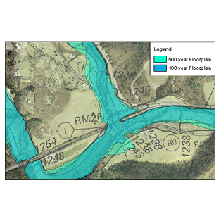
montgomery_mapmod

Published March 25, 2011 at 314 × 314 in How To Find Your Home On FEMA’s Flood Insurance Rate Maps
flood maps

Image navigation

CONTACT US

    © Copyright Montgomery Land Surveying
    Montgomery, AL
    Phone: (334) 625-9540

    Privacy Policy | Terms of Use

    Web Development and SEO by:
    N2Biz.co


    Privacy Policy | Terms of Use

    The owner of this website, USA Surveying & Engineering, LLC., provides coordination of professional land surveying and engineering services in all 50 states. The professional surveying and engineering services provided to you will be conducted by fully licensed professionals in your state.

    ↑