
Earthwork Grading Accuracy Improved Through Detailed Topographic Elevation Mapping
Shaping land for new buildings or roads needs more than just pushing dirt around. Detailed topographic elevation mapping gives every crew member clear exact numbers to follow so the finished ground matches the design perfectly. Guessing or using old rough maps often leaves slopes too steep or low spots that hold water. These small errors turn into costly fixes or safety issues later on. This piece explains how precise elevation data makes grading work faster and more reliable from start to finish.
Pre-Grading Surface Calibration Using High-Density Elevation Point Clouds
Before any work begins surveyors measure thousands of spots across the whole site to build a true picture of the ground. They use satellite tools and laser scanners to catch every tiny rise dip or uneven patch that standard maps miss. All these measurements combine into a 3D model that shows exactly how the land sits right now. Contractors use this real model to work out exactly how much soil to move, where to move it and how much extra material they will need.
This step stops teams from planning work based on outdated records that no longer fit the land. It also reveals hidden things like old buried pipes or rock outcrops that could slow digging down. Everyone uses the same clear reference so no time or money gets wasted on avoidable mistakes.
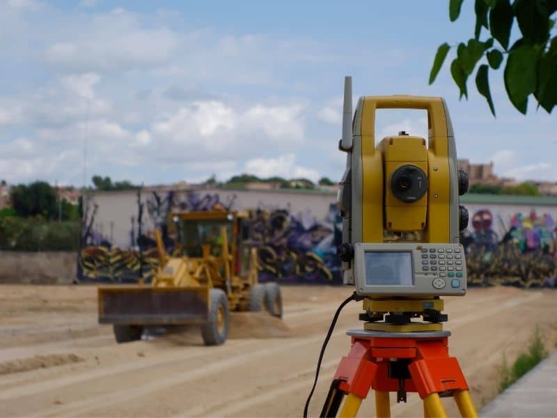
Design-to-Field Alignment Control for Construction Grading Operations
Engineers draw ideal grades on digital plans but these must fit the actual land to work well. Surveyors mark clear height targets across the site and check them against the design often. If a spot sits lower or higher than the drawing shows they tell crews straight away before too much soil gets moved. This keeps grading work locked to the planned layout for roads home bases and drainage paths.
Workers follow these marked targets instead of judging by eye or guessing how much to cut or fill. Each pass of the machine brings the ground closer to the exact height written in the plan. This steady matching stops rework and keeps the whole project moving on schedule.
Vertical Datum Consistency Checks in Multi-Phase Earthwork Projects
A vertical datum is the official starting height that all other measurements use, usually set to mean sea level. Big projects often happen in stages or bring in different teams over months or years. If one group uses a different starting point than another their numbers will not line up even if they measure carefully. Regular checks confirm that every new survey ties back to the same fixed official markers so all heights match across the whole site.
Mismatched starting points cause problems that show up long after grading ends, such as water flowing toward foundations or building pads sitting at different heights. These checks catch small gaps early so the land stays smooth and stable for every next step.
Real-Time Earthwork Deviation Detection Through Digital Elevation Comparison Models
As crews shape the land surveyors take fresh height readings and line them up against the design model. The system instantly flags spots that sit too high too low or have slopes that do not fit the plan. Common issues show up clearly right away:
- Digging deeper than the planned level
- Leaving soil too thin in areas that need extra support
- Flat patches that will trap rainwater
- Slopes that are too steep or too gentle for their purpose
Crews fix these spots immediately before they add heavy compaction or lay down pavement. This fast feedback stops errors from becoming permanent and keeps the finished ground strong.
Slope Tolerance Verification for Structural and Pavement Readiness
Different parts of a site need different slope angles to work as they should. Roads need soft steady slopes to carry water away, while building pads need to sit almost flat, and embankments need steeper stable grades. Surveyors check every finished section against strict limits set by engineering rules. They confirm that slopes neither drop too fast nor stay too flat so water drains well and soil stays firm.
These final checks happen before anyone pours concrete or lays asphalt. If slopes sit within the allowed range the site moves to the next phase. If not, crews make small adjustments to bring everything into line so the final structure stands strong for decades.
Frequently Asked Questions
How does topographic elevation mapping improve earthwork grading accuracy?
It gives exact height details so crews follow the planned grades closely and cut down mistakes during soil moving work.
What causes grading inaccuracies in earthwork projects?
Old site records, weak reference markers, equipment drift, and gaps between drawings and real ground conditions all lead to errors.
Why is vertical datum consistency important in grading work?
It ties all measurements to one shared starting point so heights match across the site and prevent drainage or foundation problems.
How is over-excavation detected during grading?
Fresh height readings get compared against the planned design to spot any areas dug deeper than needed.
Can topographic data be used with machine control systems?
Yes, 3D elevation models load directly into grading equipment to guide blades and buckets with great precision.