
Old Streets, New Utilities: Rebuilding Reliable Land Records in a Historic Downtown
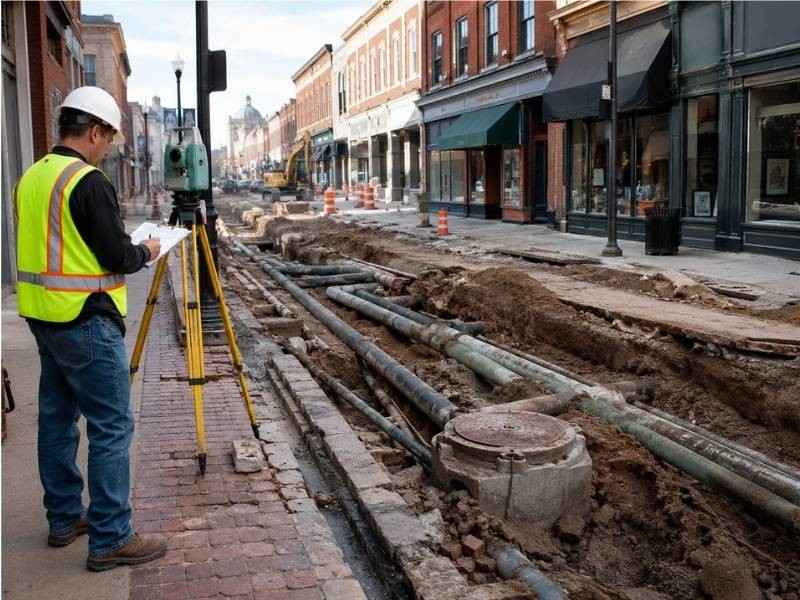
A historic downtown carries its whole past underfoot. The blocks were platted when horses pulled the freight, the water lines went in before anyone kept good maps and the sidewalks have been rebuilt so many times that nobody remembers the original street width. When new investment arrives, somebody has to sort all of it out. Rebuilding reliable land records in a downtown like this is careful, layered work, and it starts with the oldest paper in the courthouse.
Following Street Lines Through Successive Generations of Plats
The original town plat drew the first version of every block. Later resubdivisions redrew pieces of it, road projects changed some widths and a few blocks got replatted entirely after fires or floods. Each generation of records shows a slightly different picture of the same ground.
The surveyor collects every version and puts them in order. Sequence matters, because a later plat can only change what its makers had the authority to change. A block corner shown three different ways across three documents is not a mystery once the dates and the authority behind each document become clear. The controlling geometry emerges from the stack, and the survey carries it forward onto the modern map.
Field evidence then tests the paper. Recovered monuments, original curb remnants and long-standing building faces either support the record geometry or push back against it, and the surveyor reconciles the two before drawing anything final.
Discovering Utility Routes That Never Matched a Recorded Easement
Downtown utilities grew by habit, not by grant. Crews a century ago laid pipe where the digging was easy, and the paperwork either never existed or never made it into the land records. Modern research turns up the mismatch constantly, and it takes several forms:
- Active lines crossing private parcels with no recorded easement anywhere in the chain
- Recorded easements describing routes the utility abandoned generations ago
- Service connections wandering far from the streets the records assume they follow
- Vaults and chambers extending under sidewalks and buildings without any documented right
Each condition needs its own answer. The survey documents the physical evidence, the title work documents the recorded rights and the gap between them becomes a known issue instead of a buried surprise. Property owners, utilities and their attorneys can then address the gap deliberately, which beats discovering it during excavation.
Using Building Faces and Sidewalks as Supporting Evidence
Downtown buildings hold their positions for a very long time. A commercial block built to the street line in 1895 has marked that line ever since, and rows of such buildings can preserve block geometry better than any single monument.
Supporting evidence still ranks below controlling evidence. A building face helps interpret where the street line ran, and it yields to original monuments, plat geometry and senior deed calls whenever they conflict. Storefronts get remodeled, walls get refaced and a building that appears original may sit on a footprint that shifted during a rebuild nobody recorded. The surveyor uses the improvements to corroborate the record, weighs each one against its history and never lets a convenient wall overrule a stronger source.
Sidewalks work the same way at lower strength. An old curb line laid to the original plat width supports the record nicely. A curb moved during a 1970s streetscape project supports nothing but the 1970s project.
Separating Public-Space Improvements From Private Ownership
Modern downtowns blur the line between public and private ground. Planters, lighting, ramps, café railings, awnings and transit shelters crowd the sidewalk zone, and the improvements rarely respect the legal boundaries beneath them. Some private features occupy public right-of-way under permits. Some public features rest on private land through agreements or through nothing at all.
The survey pulls these layers apart. It shows the right-of-way line, the parcel lines and each improvement in its true position, so every feature can be matched to whatever right supports it. Basement vaults deserve special care, since many historic buildings extend storage or coal chutes under the sidewalk, and those spaces raise ownership, maintenance and liability questions the moment a streetscape project starts. A drawing that separates the layers cleanly turns those questions into manageable ones.
Updating the Record Without Erasing Historic Evidence
A modern downtown survey should add a layer, never delete one. The new map documents current conditions, recovered monuments and resolved geometry, and it also preserves the trail that led there. Notes identify which plat controlled each block line, which corners came from original evidence and which positions carry stated uncertainty.
Future professionals inherit that trail. A surveyor working the adjacent block in thirty years reads the record, understands the reasoning and builds on it instead of starting over. Historic evidence noted but not destroyed keeps its voice, and the downtown’s land records grow more reliable with each project instead of resetting with each one. That is the entire point of the work.
Frequently Asked Questions
Can a utility line exist without a recorded easement appearing in a title search?
Yes, and downtown it happens often. Physical infrastructure and recorded rights grew separately for decades, so a clean title search proves little about what lies underground. Site investigation and utility records both need review alongside the courthouse research.
Are building walls reliable evidence of downtown property lines?
They can support an interpretation without settling it. A wall standing since the original construction carries real weight, while a refaced or rebuilt wall may not mark anything. Deeds, plats, monuments and adjoining ownership evidence get weighed with every wall.
Why do old street widths sometimes differ between maps?
Different documents captured different moments. An original dedication set one width, a later widening changed part of it and a vacation may have trimmed another block entirely. Mapping errors add noise on top, and the traveled pavement rarely matches the legal right-of-way exactly.
