
What a Topographic Survey Can Tell You About Your Land
Before any serious construction or development project begins, someone needs to understand the land itself. Not just where the boundaries are, but what the ground actually looks like. How steep is it? Where does water flow when it rains? Are there low spots that could flood a foundation? A topographic survey answers all of those questions, and it is often the first step a builder, engineer, or developer takes before drawing a single line on a plan.
What Makes a Topographic Survey Different
Most surveys focus on the edges of a property. A boundary survey, for example, tells you where your land begins and ends. A topographic survey looks at what is happening inside those edges. It measures the shape of the ground itself, recording elevation changes across the entire surface of a parcel.
The result is a topo map, a drawing that shows the highs and lows of your land using a system of lines, symbols, and elevation numbers. Where other surveys answer the question of where your property is, a topographic survey answers the question of what your land looks like from the ground up.
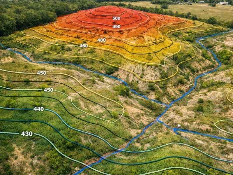
Understanding Contour Lines
The most important feature of a topo map is its contour lines. A contour line is a curved line that connects all points on a map that share the same elevation. Every point sitting on that line is at the exact same height above sea level.
Here is how to read them:
- Lines close together mean the ground rises or falls steeply in that area.
- Lines spread far apart mean the ground is relatively flat.
- Circular lines often indicate a hill, a mound, or a depression in the ground.
- The contour interval is the difference in elevation between each line. A map with a two foot contour interval means each line represents a two foot change in height.
Once you understand contour lines, a topo map tells you a great deal about a piece of land before you ever set foot on it. You can spot ridges, valleys, drainage paths, and flat buildable areas just by reading the lines.
What a Topo Survey Reveals About Your Land
A topographic survey goes beyond drawing lines on paper. It gives property owners, engineers, and builders specific information they cannot get from any other type of survey.
Drainage and Water Flow. Water always follows the lowest path. A topo survey shows exactly where that path is on your property. This matters when placing a foundation, designing a driveway, or planning a drainage system. Building in a low spot without accounting for water flow is one of the most common and costly mistakes in residential and commercial construction.
Slope and Grading Requirements. If your land slopes significantly, any construction project will require grading, which means moving earth to create a level surface. A topo survey gives engineers the data they need to calculate how much dirt must be moved, where it goes, and what it will cost. Without this data, grading estimates are little more than guesses.
Flood Risk and Low Areas. Low areas on a topo map are the first places to flood during heavy rain. Identifying them early allows designers to route drainage away from structures, raise finished floor elevations, or reconsider site layouts entirely. This is especially important in central Alabama, where heavy rainfall is common and flood risk is a real concern for many properties.
Existing Features and Improvements. A topo survey also records the location and elevation of existing features on the land, including trees, retaining walls, utility lines, curbs, and any structures already on the site. This gives designers an accurate starting point rather than building a plan around assumptions.
How LiDAR Has Changed Topographic Surveying
One of the biggest advances in topographic surveying in recent years is LiDAR, which stands for Light Detection and Ranging. LiDAR works by sending out rapid pulses of laser light and measuring how long each pulse takes to bounce back. By collecting millions of these measurements, the system builds an extremely detailed three-dimensional model of the ground surface.
LiDAR can be mounted on a drone, an aircraft, or a ground-based unit, and it collects data far faster than traditional field methods. For large or heavily wooded properties, this is a significant advantage. LiDAR pulses can pass through gaps in tree canopies and still reach the ground below, giving surveyors accurate elevation data even in areas that are difficult to access on foot.
For property owners, LiDAR-based topographic surveys mean faster turnaround times, higher accuracy, and more detailed maps than were possible just a decade ago.
When Do You Need a Topographic Survey?
A topographic survey is not needed for every property transaction, but it is essential in several situations:
- You are planning to build a home, commercial building, or accessory structure on undeveloped land
- Your property has significant slope, drainage issues, or areas prone to standing water
- You are applying for a grading or land disturbance permit
- A civil engineer or architect has requested topo data before designing your project
- You are subdividing land and need elevation data for infrastructure planning
- You want to understand flood risk on a property before purchasing it
How Much Does a Topographic Survey Cost?
The cost of a topographic survey depends on the size of the property, the density of existing features, and the level of detail required.
| Property Size | Typical Cost | Timeframe |
| Small Residential Lot | $500 to $1,200 | 3 to 5 business days |
| One to Five Acres | $1,200 to $3,500 | 1 to 2 weeks |
| Five to Twenty Acres | $3,500 to $8,000 | 2 to 4 weeks |
| Large or Complex Site | $8,000 and up | 4 to 8 weeks |
Topo surveys are often ordered together with a boundary survey, especially when a project is in early planning stages. Combining both surveys with one firm can reduce overall cost and turnaround time.
Frequently Asked Questions
Do I need a topographic survey before building a house?
In many cases, yes. If your lot has any slope, drainage concerns, or grading requirements, your engineer or architect will need topo data before they can design your project. Some local jurisdictions also require a topo survey as part of the permitting process.
What are contour lines on a survey map?
Contour lines connect points of equal elevation across a map. They show the shape of the land by indicating where the ground rises and falls. Lines close together mean steep terrain. Lines spread apart mean flat or gently sloping ground.
How does LiDAR improve a topographic survey?
LiDAR collects millions of precise elevation measurements in a fraction of the time traditional methods require. It works well in wooded or hard to access areas and produces highly detailed three-dimensional models of the ground surface. For large properties, LiDAR significantly reduces field time and improves accuracy.