
Find Your Property Lines Before You Build, Fence, or Dig
Most people assume their property lines are obvious. Maybe there is an old fence, a row of trees, or a concrete curb that seems to mark the edge. The truth is, none of those things are legally reliable. If you are planning to build, fence, or dig on your property, knowing exactly where your lines are is not optional. It is essential.
What Are Property Line Markers?
Property line markers are physical objects placed in the ground to show where one property ends and another begins. They are set by licensed land surveyors during a boundary survey and serve as the official, on-the-ground reference for your property corners.
Common types of markers include:
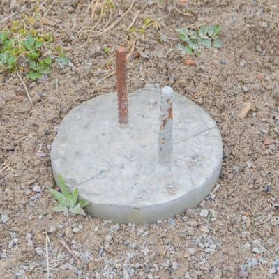
- Iron pins or rebar: Small metal rods driven into the ground, usually at each corner of your lot. These are the most common types found in residential neighborhoods.
- Concrete monuments: Larger and more permanent than iron pins, these are often used for subdivision corners or public land boundaries.
- Plastic caps: A small colored cap placed over an iron pin that identifies the surveying firm or surveyor who set it.
- Chiseled marks: Cut into concrete, asphalt, or rock where a pin cannot be driven into the ground.
Markers are often flush with the ground or slightly below the surface. Years of lawn maintenance, soil movement, and landscaping can bury them completely. Do not assume a marker is gone just because you cannot see it.
Where to Start Looking for Your Property Lines
Before calling a surveyor, there are a few steps you can take on your own.
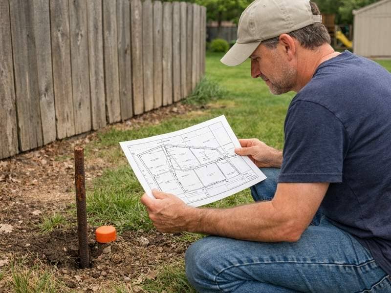
Check Your Recorded Plat. A plat is a scaled map of your subdivision or land parcel recorded with the county. It shows the dimensions of your lot, the location of easements, and the layout of surrounding properties. You can request a copy from the Montgomery County Probate Court or find it through the county’s online records portal. Reading a plat takes a little practice, but it will tell you the exact measurements of your lot so you know where to look for markers.
Review Your Deed. Your deed contains a legal description of your property. For subdivision lots, this is usually simple, referencing a lot number and recorded plat. For rural or older properties, the description may use metes and bounds, which lists bearings and distances from a starting point. A metes and bounds description can be difficult to follow without surveying experience, but it gives you the raw data a surveyor uses to locate your lines.
Use Online Mapping Tools. Several free tools can give you a general idea of where your property lines fall. The Montgomery County GIS map and tools like Regrid or Google Earth allow you to view parcel boundaries overlaid on satellite imagery. These tools are useful for a rough visual reference, but they are not survey-accurate. Do not use them to make final decisions about where to build or install a fence.
Search for Iron Pins With a Metal Detector. If your plat shows where corners should be, a basic metal detector can help you locate buried iron pins. Walk the perimeter of your lot based on the dimensions shown on your plat and sweep the ground at each corner location. This works well in established neighborhoods where pins were set during the original subdivision.
When Online Tools Are Not Enough
Free online tools and plat maps are a good starting point, but they have real limits. Parcel boundaries shown on county GIS maps are often based on deed records, not actual field measurements. They can be off by several feet, which is more than enough to cause a serious problem if you are building close to a line.
You should contact a licensed land surveyor when:
- You cannot locate your markers after searching
- Your plat dimensions do not match what you find on the ground
- You are planning to build a fence, addition, pool, or any structure near a property line
- A neighbor is disputing where the line is
- You are buying or selling the property
- Your property is rural, irregularly shaped, or has a complex deed history
A licensed surveyor will locate or reset your corners, confirm your boundaries against the recorded deed, and give you a certified plat you can rely on legally.
What to Do If Your Markers Are Missing
Missing markers are more common than most people expect. Construction, landscaping, and even routine lawn care can disturb or bury them over time. In some cases, markers are removed intentionally, which is actually illegal in Alabama.
If you cannot find your markers, do not guess and do not rely on fences or landscaping as a substitute. The right move is to hire a licensed land surveyor to locate or re-establish your corners. This is a standard part of a boundary survey and gives you legally defensible markers you can build from with confidence.
Frequently Asked Questions
Can I find my property lines for free online?
Yes, partially. County GIS maps and tools like Regrid give you a visual approximation of your parcel boundaries. They are useful for a general overview but are not survey-accurate. Never use them as the sole basis for construction, fencing, or legal decisions.
What do property line markers look like?
Most residential markers are iron pins or rebar driven into the ground at each corner of your lot. They are often capped with a small colored plastic cap that identifies the surveyor who set them. They may be flush with the ground or slightly buried.
What should I do if I cannot find my property markers?
Hire a licensed land surveyor. They will locate existing markers or set new ones based on your recorded deed and plat. Do not guess or rely on neighboring fences as a substitute.
Are online property line tools accurate enough to build a fence?
No. Online parcel maps can be off by several feet. For anything involving construction or fencing near a property line, you need a certified boundary survey performed by a licensed land surveyor.
Can my neighbor move or remove a property line marker?
No. Moving, removing, or destroying a property line marker is a criminal offense in Alabama under state law. If you believe a marker has been tampered with, contact a licensed surveyor and document the situation.
What is the difference between a plat and a deed?
A deed is a legal document that describes what you own and transfers ownership. A plat is a scaled map that shows how your lot is laid out in relation to surrounding properties. You need both to fully understand your property boundaries.