
Most property owners assume they know where their land ends. The deed says so, right? Not exactly. A deed describes your property in legal terms, but it does not put markers in the ground. That is what a boundary survey does, and it is something every property owner should understand before buying, building, or putting up a fence.
What Is a Boundary Survey?
When you own property, your deed includes a written description of your land. That description tells you what you own on paper, but it does not show you where your property lines are on the ground. A boundary survey closes that gap.
A boundary survey is the process a licensed land surveyor uses to measure, map, and mark the exact edges of your property. The surveyor studies your deed and public records, then uses precision equipment in the field to find your corners and confirm your boundaries. At the end, you receive a certified plat, which is a scaled drawing that shows your property lines, dimensions, and any easements.
Iron pins, rebar, or concrete monuments are set or confirmed at each corner so you can see exactly where your property begins and ends.
What Does a Boundary Survey Show?
A completed boundary survey gives you a clear, legal picture of your property. It shows:
- The exact dimensions and square footage of your lot
- The location of all property corners, marked with physical monuments
- Encroachments, which are structures from a neighboring property that cross your line
- Easements, which are utility corridors or access routes that run through your land
- Any conflicts between your deed and neighboring deeds
- How your property relates to nearby roads, waterways, or public rights-of-way
When Do You Need a Boundary Survey?
You need a boundary survey any time the exact location of your property lines matters legally or practically. The most common situations include:
Buying or Selling Property A title company or lender may require a survey before closing. Even when it is not required, a boundary survey protects you from purchasing a property whose actual boundaries differ from what you were shown.
Building a Fence This is one of the most common reasons homeowners call a land surveyor. A fence built even a few inches over the property line can lead to a legal dispute. A boundary survey for a fence typically costs $400 to $700 and can prevent thousands of dollars in legal fees down the road.
Adding a Structure or Pool Local zoning codes require setbacks, which are minimum distances between structures and property lines. Without a boundary survey, you may unknowingly violate those rules and put your building permit at risk.
Resolving a Property Line Dispute Neighbor disagreements over property lines are more common than most people think. A certified boundary survey by a licensed surveyor provides the legally recognized answer to where a property line is located.
Dividing or Subdividing Land Any time a parcel is split into two or more lots for sale, inheritance, or development, a licensed surveyor must establish the new legal boundaries and record a plat with the county.
How Much Does a Boundary Survey Cost?
Costs vary depending on the size of your property, its location, and the complexity of the deed history.
| Survey Type | Typical Cost | Timeframe |
| Residential Lot | $500 to $1,500 | 3 to 7 business days |
| Acreage or Rural Property | $1,500 to $5,000+ | 1 to 3 weeks |
| Commercial Property | $2,000 to $10,000+ | 2 to 4 weeks |
| ALTA/NSPS Survey | $3,000 to $20,000+ | 3 to 6 weeks |
Several factors influence the final price:
- Lot size and shape: Larger or irregular parcels require more field time.
- Terrain and vegetation: Heavily wooded or hilly land adds time and cost.
- Deed complexity: Older deeds with complex descriptions require more research.
- Prior survey records: Rural properties with no prior survey history often cost more.
- Rush requests: Expedited surveys usually carry an additional fee.
Always ask your surveyor what is included in their quote. Field work, corner monuments, a certified plat drawing, and recording fees may or may not be bundled into the price.
How the Survey Process Works
A boundary survey happens in three stages:
1. Research and Record Review Before any field work begins, the surveyor pulls your deed, neighboring deeds, recorded plats, and easement records from the county courthouse. This step establishes the legal basis for your boundaries.
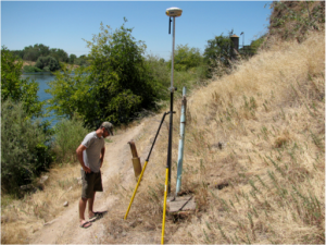
2. Field Survey The surveyor uses GPS receivers, a total station, or LiDAR equipment to locate existing monuments, measure distances and angles, and calculate each boundary corner. New iron pins are set at corners that are missing or unclear.
3. Certified Plat Preparation Back in the office, the surveyor processes the field data using CAD software. The result is a certified plat drawing that shows your property, its dimensions, bearing angles, monuments, and easements. The surveyor’s seal and signature make it a legally binding document.
The full process typically takes 3 to 7 business days for a standard residential lot.
How to Choose a Licensed Boundary Surveyor
When hiring a surveyor, keep these steps in mind:
- Verify the surveyor holds an active Alabama Professional Land Surveyor (PLS) license through albels.alabama.gov.
- Confirm they carry professional liability insurance.
- Ask whether they have experience with your county and deed type.
- Request a written quote that lists all services and deliverables.
- Ask how long the survey will take and when you will receive the certified plat.
Frequently Asked Questions
Is a boundary survey the same as a property survey?
The two terms are often used interchangeably. However, some surveyors use “property survey” to describe a simpler location survey that shows existing structures but does not set new corner monuments. If you need your corners physically marked, ask specifically for a boundary survey.
How long does a boundary survey take?
A standard residential boundary survey takes 3 to 7 business days. Larger or rural properties with complex deed histories can take 2 to 4 weeks.
Do I need a new survey if one was already done on the property?
Not always. It depends on when the prior survey was done and whether any changes have occurred since then, such as new fences, structures, or recorded easements. A licensed surveyor can review the existing survey and tell you whether it is still reliable for your needs.