
↓
 

Montgomery Land Surveying

Land Surveying in Montgomery, Montgomery County, Alabama

Montgomery Land Surveying
  • Home
  • ALTA Survey
  • Boundary Surveying
  • Construction Survey
  • Drone LiDAR Mapping
  • Elevation Certificate
  • Land Surveying
  • Topographic Survey
  • Civil Engineering
    • Expert Witness
    • Elevation Certificate – LOMA
  • Contact Us
  • Blog
Home - Page 5 << 1 2 3 4 5 6 7 … 13 14 >>

Post navigation

← Older posts
Newer posts →

Survey Records Research for Properties Affected by Government and Institutional Land Transfers

Montgomery Land Surveying Posted on July 23, 2026 by MontgomeryLSJuly 22, 2026
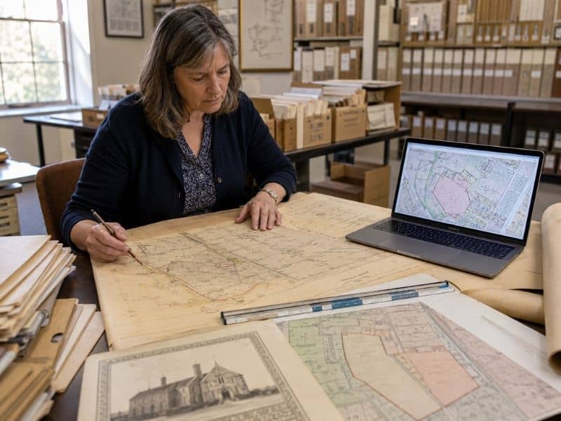
Researcher comparing historical institutional land maps with current government parcel records.

Survey records research untangles ownership when land has passed through government agencies, schools, hospitals, or churches. These transfers rarely look like a normal home sale, and they can leave behind rights and limits that a basic title search misses. A researcher traces the full history and reads the unusual documents that shaped it. That work builds the base for accurate fieldwork later.

Following the Chain Across Public and Private Owners

The research follows land as it moves between private hands and public ones. Deeds, purchases, releases, dedications, and exchanges all form links in the chain, and institutions add their own kinds of records. When a parcel once belonged to a school district or a hospital, its history often branches in ways a homeowner never would. Tracing every link keeps the current picture honest.

Public and private records live in different offices, which makes the search harder. A researcher who knows where to look can put the full story together. Missing one link can hide a right that still binds the land today.

Reading Documents That Do More Than Transfer Land

Institutional transfers use documents that go past a simple deed. Resolutions, ordinances, condemnation files, surplus-property actions, and reversion clauses can each shape who owns what. A reversion clause, for example, may hand land back to an earlier owner if a condition fails. Spotting these documents matters, because they carry legal weight a plain deed never mentions.

These records often hold the most important details. A dedication might grant public use while keeping the underlying title. Reading them closely reveals rights that a quick search would skip.

Matching Old Descriptions to Today’s Maps

Old records describe land in old terms, and connecting them to modern maps takes care. A researcher compares names, bearings, distances, next-door owners, roads, and monuments across documents written decades apart. Boundaries described in one era rarely match today’s coordinate systems cleanly. Careful matching keeps a modern map from misplacing an old line.

Names change, roads move, and monuments disappear over time. The researcher accounts for all of it, lining up the past with the present. That work turns a stack of old paper into a base the crew can use.

Finding Rights That Outlived the Transfer

Some rights survive the main deal, and the research hunts for them. Retained access, utility rights, use limits, and reversion interests can all continue long after the main transfer closes. These leftovers surprise owners who assumed a clean handoff. Finding them early keeps a future project from running into an old right.

A partial release can leave a piece of an interest attached to a parcel. The research spots those pieces so the current owner knows the full picture. What survived matters as much as what changed.

Turning Research Into a Field Plan

The gathered records guide what the surveyor does on the ground. The findings tell the crew which evidence to trust first, which uncertain areas to check, and what extra documents the job may need. Because the research points the way, fieldwork runs smoothly instead of chasing dead ends. Good research and good fieldwork feed each other.

Frequently Asked Questions

Are all government property transfers recorded like normal deeds?

No. Many involve orders, resolutions, condemnation files, or legislative actions kept in offices separate from the deed records. A full search often reaches past the recorder’s office to find them.

Can a surveyor decide whether a reversion clause still holds?

A surveyor can find a reversion clause and map the land it affects, but whether it still holds is a legal question for an attorney. The survey documents the right, and legal counsel reads it.

Why are institutional parcels sometimes hard to trace?

They may have been pieced together over time, renamed, partly sold off, or left off the tax rolls, and recorded across several systems. Each of those wrinkles can hide the chain, which is why the research takes patience.

Posted in land surveying | Tagged Land Surveying

Old Streets, New Utilities: Rebuilding Reliable Land Records in a Historic Downtown

Montgomery Land Surveying Posted on July 15, 2026 by MontgomeryLSJuly 14, 2026
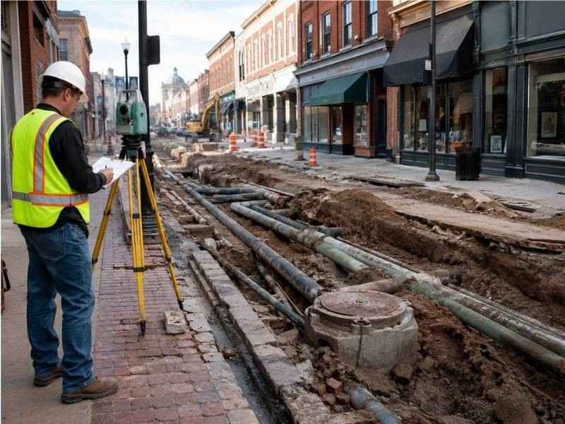
Surveyor documenting exposed utility lines and property evidence during reconstruction on a historic downtown street.

A historic downtown carries its whole past underfoot. The blocks were platted when horses pulled the freight, the water lines went in before anyone kept good maps and the sidewalks have been rebuilt so many times that nobody remembers the original street width. When new investment arrives, somebody has to sort all of it out. Rebuilding reliable land records in a downtown like this is careful, layered work, and it starts with the oldest paper in the courthouse.

Following Street Lines Through Successive Generations of Plats

The original town plat drew the first version of every block. Later resubdivisions redrew pieces of it, road projects changed some widths and a few blocks got replatted entirely after fires or floods. Each generation of records shows a slightly different picture of the same ground.

The surveyor collects every version and puts them in order. Sequence matters, because a later plat can only change what its makers had the authority to change. A block corner shown three different ways across three documents is not a mystery once the dates and the authority behind each document become clear. The controlling geometry emerges from the stack, and the survey carries it forward onto the modern map.

Field evidence then tests the paper. Recovered monuments, original curb remnants and long-standing building faces either support the record geometry or push back against it, and the surveyor reconciles the two before drawing anything final.

Discovering Utility Routes That Never Matched a Recorded Easement

Downtown utilities grew by habit, not by grant. Crews a century ago laid pipe where the digging was easy, and the paperwork either never existed or never made it into the land records. Modern research turns up the mismatch constantly, and it takes several forms:

  • Active lines crossing private parcels with no recorded easement anywhere in the chain
  • Recorded easements describing routes the utility abandoned generations ago
  • Service connections wandering far from the streets the records assume they follow
  • Vaults and chambers extending under sidewalks and buildings without any documented right

Each condition needs its own answer. The survey documents the physical evidence, the title work documents the recorded rights and the gap between them becomes a known issue instead of a buried surprise. Property owners, utilities and their attorneys can then address the gap deliberately, which beats discovering it during excavation.

Using Building Faces and Sidewalks as Supporting Evidence

Downtown buildings hold their positions for a very long time. A commercial block built to the street line in 1895 has marked that line ever since, and rows of such buildings can preserve block geometry better than any single monument.

Supporting evidence still ranks below controlling evidence. A building face helps interpret where the street line ran, and it yields to original monuments, plat geometry and senior deed calls whenever they conflict. Storefronts get remodeled, walls get refaced and a building that appears original may sit on a footprint that shifted during a rebuild nobody recorded. The surveyor uses the improvements to corroborate the record, weighs each one against its history and never lets a convenient wall overrule a stronger source.

Sidewalks work the same way at lower strength. An old curb line laid to the original plat width supports the record nicely. A curb moved during a 1970s streetscape project supports nothing but the 1970s project.

Separating Public-Space Improvements From Private Ownership

Modern downtowns blur the line between public and private ground. Planters, lighting, ramps, café railings, awnings and transit shelters crowd the sidewalk zone, and the improvements rarely respect the legal boundaries beneath them. Some private features occupy public right-of-way under permits. Some public features rest on private land through agreements or through nothing at all.

The survey pulls these layers apart. It shows the right-of-way line, the parcel lines and each improvement in its true position, so every feature can be matched to whatever right supports it. Basement vaults deserve special care, since many historic buildings extend storage or coal chutes under the sidewalk, and those spaces raise ownership, maintenance and liability questions the moment a streetscape project starts. A drawing that separates the layers cleanly turns those questions into manageable ones.

Updating the Record Without Erasing Historic Evidence

A modern downtown survey should add a layer, never delete one. The new map documents current conditions, recovered monuments and resolved geometry, and it also preserves the trail that led there. Notes identify which plat controlled each block line, which corners came from original evidence and which positions carry stated uncertainty.

Future professionals inherit that trail. A surveyor working the adjacent block in thirty years reads the record, understands the reasoning and builds on it instead of starting over. Historic evidence noted but not destroyed keeps its voice, and the downtown’s land records grow more reliable with each project instead of resetting with each one. That is the entire point of the work.

Frequently Asked Questions

Can a utility line exist without a recorded easement appearing in a title search?

Yes, and downtown it happens often. Physical infrastructure and recorded rights grew separately for decades, so a clean title search proves little about what lies underground. Site investigation and utility records both need review alongside the courthouse research.

Are building walls reliable evidence of downtown property lines?

They can support an interpretation without settling it. A wall standing since the original construction carries real weight, while a refaced or rebuilt wall may not mark anything. Deeds, plats, monuments and adjoining ownership evidence get weighed with every wall.

Why do old street widths sometimes differ between maps?

Different documents captured different moments. An original dedication set one width, a later widening changed part of it and a vacation may have trimmed another block entirely. Mapping errors add noise on top, and the traveled pavement rarely matches the legal right-of-way exactly.

Posted in land surveying | Tagged Land Surveying

When an Elevation Certificate Becomes Part of Floodplain Planning

Montgomery Land Surveying Posted on July 8, 2026 by MontgomeryLSJuly 11, 2026
Project team reviewing property plans for Elevation Certificate and floodplain planning decisions.

Most people meet an Elevation Certificate through flood insurance, but the document does far more than set a premium. It records exactly how high a building sits relative to the ground and the flood level around it, and that measurement feeds real planning decisions in flood-prone areas. An owner weighing a renovation, an addition or a repair leans on those numbers to know what’s practical. The certificate turns a vague sense of flood risk into specific elevation facts a project can be built around.

Connect Building Elevation Data With Floodplain Review

Floodplain review runs on elevations, and the certificate supplies them in a form officials and engineers trust. It ties a building’s measured height to the surrounding flood context, so a project team can see where the structure stands in relation to expected water levels. That link is the starting point for any flood-area planning.

The value reaches past insurance paperwork. Knowing how a building sits within the floodplain shapes what improvements make sense and which ones invite trouble. The certificate gives that judgment a factual base.

Review Structure Position Before Improvements Are Proposed

A building’s current height and placement steer what an owner can safely do to it. In a flood-prone area, an addition or major repair has to reckon with how high the existing structure sits. The certificate lays out that position, so proposals start from reality.

This review saves owners from planning into a problem. An improvement that ignores the building’s elevation might run into requirements it can’t meet. Checking the structure’s position first keeps the proposal grounded.

Support Permit Conversations With Clear Elevation Facts

Permit review in a flood area tends to circle back to elevation questions, and clear facts move those conversations along. Local officials and project teams can point to certified numbers instead of debating estimates. That clarity keeps the process focused.

For an owner, having the facts ready is practical leverage. Rather than facing repeated requests for elevation information, they supply a document that answers the question directly. Solid numbers keep permit talks from stalling.

Compare Finished Floor Levels With Nearby Ground Conditions

How a building’s finished floor relates to the land around it drives many flood-area decisions. A floor set well above the surrounding grade behaves differently in a flood than one sitting closer to it. The certificate captures that relationship, so planning reflects the real gap between structure and ground.

That comparison informs sensible choices. Understanding where the floor sits against the land helps an owner judge which improvements add protection and which add exposure. The measurement makes those trade-offs visible.

Use Certified Information Before Investing in Property Changes

Before pouring money into upgrades, repairs or site work, an owner benefits from knowing the elevation facts. Certified information tells them what they’re working with, so the investment matches the property’s real situation. Spending guided by data beats spending guided by hope.

That knowledge protects the budget. A repair or upgrade planned around accurate elevations avoids the nasty surprise of a requirement discovered mid-project. Understanding the numbers first keeps the investment sound.

Frequently Asked Questions

Is an Elevation Certificate only for flood insurance?

No. Insurance is the common use, but the same measured elevations also support planning, permitting and property decisions. The document that helps set a premium can just as easily guide a renovation or a purchase in a flood-prone area.

Can elevation data affect renovation plans?

Yes. Measured building elevations can influence which improvements are practical or allowed in a flood area. A renovation that respects the structure’s height stands on firmer ground than one that ignores it.

Who may ask for an Elevation Certificate during planning?

A range of parties. Lenders, insurers, local officials, buyers and property owners may all call for the certificate, each using the elevation facts to inform a decision on their side of a project or transaction.

Should elevation information be reviewed before buying a floodplain property?

It’s wise to review it. The certificate helps a buyer understand flood risk and any future requirements tied to the building’s height, which supports a clearer decision before committing to a floodplain property.

Posted in elevation certififate | Tagged elevation certificate

Post navigation

← Older posts
Newer posts →
Get Quote Button
© Boxer Survey USA
Montgomery Land Surveying
Montgomery, AL
Phone: (334) 625-9540

Web Development and SEO by:
AuburnBusiness.com, LLC


Privacy Policy | Terms of Use

The owner of this website, Boxer Survey USA, provides coordination of professional land surveying and engineering services in all 50 states. The professional surveying and engineering services provided to you will be conducted by fully licensed professionals in your state.

↑